Punta Arenas and Tierra del Fuego


The province of Tierra del Fuego is located to the east of the Region of Magallanes and Chilean Antarctica, where the city of Punta Arenas is the port and capital. It has more than 29 thousand acres of land and its capital city is Porvenir.
Tierra del Fuego corresponds to the west of the island that lies south of the Estrecho de Magallanes (Strair of Magallanes). To the south is the Beagle channel, while to the east is the Atlantic Ocean and the Pacific Ocean to the west. It is shared by Chile and Argentina .
The Chilean zone has the Cordillera de Darwin, which has some of the highest points of the island, including Mount Shipton with 2469 meters of altitude. From this mountain glaciers we can see ice falling into the southern waters of the sea. An example of this is the Pia Glacier which is located on the Beagle Channel.
It also has fjords in the contact zones of the Andes to the Pacific Ocean coastline. It has several rivers that end in the Beagle, Atlantic or Pacific oceans and the Estrecho de Magallanes (Strait of Magallanes. Some of them are the Rio Grande, Condor Paralelo and Grande which are known to be excellent for fishing practice.
The climate of this region is classified as subpolar oceanic, with short, cool summers and long winters, heavy and abundant rainfall, and is also characterized by the presence of strong winds. Because of its latitude it only has a few hours of sun in winter (the sun rises at 09:30 and sets at around 16:00 hours), while in the summer the says last up to 22:30 .
The flora of Tierra del Fuego consists of steppes and of fresh semi-deserts, as well as sub-Antarctic forest species such as the canelo, the guaiteca, notro, ñirres and the coigue of Magallanes, being unique in the world because of their characteristics. Another peculiarity is the high speed winds that are reached in the extreme south, many of these trees grow crooke , so they are known as " flag trees ".
The fauna on the other hand consists of guanacos, fuegians, red foxes and huillín among others. The coastal area has sea lions, elephant seals and leopard seals. We can also find minke and right whales, orcas, dolphins and sperm whales. Birds in the area include the condor, the king penguins of Magallanes and barbijo, gulls, albatrosses and owls among others.
Punta Arenas is a modern city in the Chilean Patagonia, with excellent services and service centers, along with a "Zona Franca" where you can buy products at lower prices. It is known for providing the highest income per capita in the country and one of the best qualities of life for its inhabitants. It has wide streets with trees and buildings ofEuropean architecture.
Punta Arenas is located on the Brunswick Peninsula, which is part of the western Andes of the Patagonia and borders the Estrecho de Magallanes. Its climate has semi-arid characteristics, with low rainfall throughout the year and snow and hail in the winter. It is also highlighted by the presence of strong winds. Temperatures can reach down to very extreme measures, down to -18° C.
It is in a transition zone of coigue and beech forests, with coirones that are used for breeding sheep.
Map de Punta Arenas and Tierra del Fuego
History
When Hernando de Magallanes, in 1520 , discovered an island on the south of the Estrecho de Magallanes, he called it Tierra de los Fuegos o de los Humos by the fires that lit the selknam or onas who were the first inhabitants of this territory. Later, it was renamed Tierra del Fuego by the Spanish King Carlos I.
It was not until 1879 that the center of the island began to be explored by the liutenant of the Chilean Navy, Ramón Serrano, who traveled from the Gente Grande Bay, on the Pacific Ocean, to the San Sebastian Bay in the Atlantic Ocean.
The inhabitants of this territory were the nomadic people of selknam or onas, natives of great stature and corpulent bodies, they used bow and arrows and slingshots to hunt native animals such as guanacos and birds.
During this expedition it was discovered that the lands were ideal for cattle, as well as the findings of gold the area of Sierra Boqueron, which were quickly exploited by the early twentieth century.
The process of settlement of the area was made with the installation of cattle ranches throughout the territory, a process driven by the Chilean and Argentine governments also in the early twentieth century. However, the selknam people were cruelly persecuted by professional gold businesses and trained murderers. A Salesian missionary known as Jose Fagnano was able to find refuge in Dawson Island for a group of island natives and thus protect them from such attacks. Many could not live in captivity and died, surviving only a very small percentage of the population.
Most immigrants were Croatian and settled in the town of Porvenir, capital of the province of Tierra del Fuego, so today a large part of the population of this area are descendants of these early settlers.
In the 40s, oil was found in the Manantiales wells, located north of the island of Tierra del Fuego, which prompted the creation of a new industry and the installation of rigs, processing plants and other infrastructure. In 1976 the drilling of oil also began in the Estrecho de Magallanes.
The city of Punta Arenas meanwhile, was founded in 1848 and was chosen as the capital of the region because it had the best weather conditions and of supplies in the whole zone. This area was also territory of the selknam people as well as Yagan, kaweskar or alacalufes, tehuelches and even canoe Chonos Indians, who arrived from Chiloé.
It was early in the nineteenth century during the gold rush that the massive immigration of Europeans to the Magallanes Region began, especially Croatian, Spanish and British. A Swiss colony tried to settle in the area south of Punta Arenas but was killed off by inclement weather and disease.
Its strategic location on the route that connects the Atlantic and Pacific oceans, led this place to rapidly to become a major port, especially in the early twentieth century where mining and livestock were in their heyday.
After the opening of the Panama Canal, the port flow of Punta Arenas declined but the economy found its support in the oil industry that is used today in the area.
Currently the activity in Punta Arenas is mainly port and hydrocarbons, in addition to sheep ranching and forestry. Another aspect of the area is tourism, since from this city cruises sail to Antarctica and cover the Patagonian Channels and the glaciers of southern Chile.
Where to go
In Tierra del Fuego:
Porvenir:
It is the capital of the province of Tierra del Fuego and has interesting historical attractions and natural beauty around it. One of them is upon arrival to the city, since the access to the city is via a ferry crossing the Estrecho de Magallanes, where you can see dolphins, whales and penguins.
Among the tours that can be done is to visit a king penguin colony, which is located 114 kilometers from Porvenir as well as the Karukinka Park which is on the southern part of the island, where you can do activities like bird watching, especially flamingos and plovers, the Laguna de la Sal, famous for massive amounts of UFO sightings in 1978 and other attractions.
In the center of Porvenir we visit sites of historical significance such as the Fernando Cordero Rusque Museum, with collections of wildlife of Tierra del Fuego and archaeological remains, like a mummy with an undetermined ethnicity named Kela that dates back to the fifteenth century, and the Plaza de Armas with the San Francisco de Sales Church.
Circuito de Oro: (Gold Circuit)
Following the Cordon Baquedano you can tour this historic circuit dating that dates back to the time when gold mining was conducted in the province. It is located approximately 115 kilometers from Porvenir.
Cerro Sombrero: (Sombrero Hill)
Located north of Tierra del Fuego, it is an old oil field, where you can find ancient structures that correspond to its removal, since the first oil well in the region was discovered here.
Next to the Cerro Sombrero (Sombrero Hill) you find Side River, with ideal conditions for salmon fishing.
Besides this, it features 15 kilometers of inter-oceanic beaches, that is to say water found at the junction of the Atlantic and Pacific oceans and are the habitat of marine fauna.
Parque Nacional Alberto de Agostini: (Alberto de Agostini National Park)
It has over 1,400 acres and is the third largest national park in Chile. It consists of the archipelago of the islands south of the Estrecho de Magallanes and west of the Navarino Island .
Its main attraction is the Cordillera of Darwin, which runs through its territory with glaciers and ice fields such as the Pia, Garibaldi and Marinelli Glaciers, among others. It also has beautiful exuberant green forests that are located in the foothills of the Andes, with species such as canelo, beech and coigues, plus southernmost flora such as fungi, lichens and mosses.
It is the habitat of marine fauna such as albatrosses, petrels and cormorants as well as elephant seals, otters and nutria.
A curiosity of the Alberto Agostini Park is that it is found printed on the back of the 10,000 Chilean pesos bills.
Glaciar Marinelli:
It is the largest in the area and has stunning ice walls that are over 40 feet high. It is located in Ainsworth Bay and is part of the Cordillera of Darwin.
Lago Blanco:
It is located 218 kilometers southeast of Porvenir and offers a free camping area for those who want to stay at its shores. You can take excursions like hiking up Cerro Cuchillo that has 800 meters of altitude, sport fishing for rainbow and brown trout and observe beavers and their dams.
Cordillera de Darwin:
This ice covered mountain is located inside the Alberto De Agostini National Park , southeast of Tierra del Fuego. It corresponds to the southern end of the Cordillera de los Andes. It has the highest peaks of the southern area, the largest being Shipton with more than 2400 meters of altitude.
Bahía Lomas:
This wetland allows birdwatching of native wildlife in the area and is located north of Tierra del Fuego. Some species that can be spotted are the beach plover, straight bill curlew, the plover of Magallanes and the Chilean flamingo. It is also known as a whale beaching site, such as black orca and the long-finned pilot whale.
Cabo de Hornos:
Discovered in 1616 by Dutch owners in search of a path connection between the Atlantic and Pacific, is considered the southernmost part of South America. It is a dangerous area for navigation, with strong waves and winds, plus the presence of icebergs. There is a sculpture of an albatross in flight in tribute to the sailors who lost their lives trying to get around it.
Circuito Vicuña en el Canal de Beagle:
In this area you can find snook and mackerel with your hands, as they remain on the shore at low tide, in addition to hiking between virgin forests, stunning glaciers and hidden lakes.
Circuito Histórico Bahía Inútil:
It lies south of Porvenir, crossing the Santa Maria Lake which corresponds to a waterfowl reserve, habitat of black-necked swans, flamingos and coots.
In Punta Arenas:
Plaza de Armas Benjamín Muñoz Gamero:
It is located in the downtown area of the city and in it we can see the Monumento al Ovejero (Shepherd Memorial), the sculpture of Hernando de Magallanes which stands 9 meters high together with an indigenous ona a tehuelche and a mermaid. A curiosity of the sculpture is the belief of kissing the finger of the Ona Indian for good luck.
Museo del Recuerdo:
This outdoor museum allows you to see machinery, tools and buildings from the era of the late nineteenth and early twentieth century at the time of Croatian immigration.
Museo Regional Salesiano Maggiorino Borgatello:
It is a museum that was inaugurated in the nineteenth century, with archaeological collections, samples of flora and fauna and historical documents.
Zona Franca:
It is the commerce center and it is located north of Punta Arenas and is famous because it allows you to buy tax free products such as perfumes, electronics, clothing and even automobiles.
Monumento al Inmigrante Croata:
This sculpture was built in 1970 in honor of the Croatian immigrants who arrived during the second half of the nineteenth century. These settlers developed many of the activities in the area such as masonry and navigation and most of the inhabitants of Punta Arenas are descendants of these early families.
Cementerio de Punta Arenas:
Opened in 1894 and is highlighted because of its beautiful English styles, with cypresses, beautiful gardens and luxurious mausoleums built by the wealthy families of the early twentieth century.
Reserva Nacional Magallanes:
Also known as Rio de las Minas or Japanese Park, was founded in 1932 and has an area of over 20 thousand acres. It possesses beautiful Nothofagus forests that provide habitat for native fauna such as guanacos, ducks, flamingos and condors. It is located 7.5 kilometers west of Punta Arenas.
Estancia San Gregorio:
The "estancia", which opened in 1876 , was the largest in Chile, with a beautiful French-style house, a train and a dock for transporting wool. It is located 124 kilometers north of Punta Arenas, on the west shore of the Estrecho de Magallanes.
Club Andino:
This ski resort is located in Cerro Mirador, 5 miles west of Punta Arenas. It has 14 ski slopes that have descents that overlook the Estrecho de Magallanes.
During the summer its facilities are used for hiking and mountain biking.
Reserva Nacional Laguna Parrillar:
It is located 50 kilometers south of Punta Arenas with an area of over 18 thousand acres. It features a lake surrounded by a beech forest.
Fuerte Bulnes:
It was built to protect the sovereignty of Chile at the southernmost end. It is located 60 kilometers south of Punta Arenas and has beautiful natural areas around it.
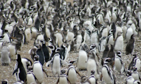
Pinguineras Seno Otway:
This area is located 65 kilometers northwest of Punta Arenas, in the Seno Otway, every year Magellanic penguins come to nest here so habits and the growth of their seeds can be observed.
Monumento Nacional Los Pinguinos:
In Santa Marta and Magdalena Islands we find this Natural Reserve where another important penguin colony can be found, where there are over 60,000 birds nesting in this area and are also shared with other species such as cormorants and sea lions. To get from Punta Arenas you must travel 65 kilometers by boat, a journey that takes about 2 ½ hours.
Isla Carlos III:
Located in the Estrecho de Magallanes and 190 kilometers fromPunta Arenas, is one of the best places to observe humpback whales that swim from the coast of Colombia to the Antarctic. They are characterized by their acrobatic leaps that provide a wonderful show.
Also, in this area of confluence of the Atlantic and Pacific Ocean other species can be seen such as minke whales, sea lions, elephant seals, Magellanic penguins, albatrosses, Chilean skua and other inhabitants of these icy spots.
In the Isla Carlos III (Carlos the Third Island) the Francisco Coloane Marine Park is located and inaugurated in 2003, declaring the area as a Protected Area. In its 67 thousand acres we can also find ñirres, coigues, and canelo forests as well as peat vegetation, consisting of small ferns and mosses.
The park seeks to preserve the life of its inhabitants and take care of their ecosystem composed of beaches, coasts, glaciers and sea. In some areas you can do recreational activities such as hiking and kayaking.
To do
In the southernmost region of Chile we can discover wonderful landscapes, unique mountain ranges, glassy lakes, towering glaciers and snowdrifts and fjords of Patagonian canal, as well as flora and fauna adapted to the extreme climatic conditions of the area.
Because of its wealth of natural areas, it is ideal for all kinds of outdoor activities like hiking, sailing, mountain climbing, mountain biking, kayaking, photography, and many other things.
It is worth taking the cultural tours where you can see the history of gold mining and oil exploration in addition to the culture of the settlers, especially Croats who came to settle in Tierra del Fuego.
The city of Porvenir, with its Cordero Rusque Museum is another must see attraction because it was the culture and background of the selknam and onas, the first inhabitants of the island which began to diminish with the arrival of Europeans into their territory.
One of the most beautiful places is Alberto de Agostini National Park, where the Cordillera de Darwin is located, with Magellanic forests in both slopes and immense glaciers and snowfields on the peaks; it is an area to completely appreciate the unspoiled nature of Southern Chile.
Cabo de Horno reminds us that many sailors risked and lost their lives while trying to conquer the unpredictable waters of one of the wildest areas of the world where the winds reach high velocities and the waves push boats into the rocky fjords.
Hundreds of species of native wildlife live in this natural beauty such as the Chilean flamingos, various types of penguins and whales, sea lions and elephant seals, cormorants, seagulls, shore plovers, great albatrosses and petrels, to name a few.
Punta Arenas, the capital of the Magallanes region, shows an industrialized and modern city, which stands out for the high activity of its port, the presence of a tax free zone where commercial products without tax can be bought and multiple historic sites that show the stages from its inauguration to its present day.
In Punta Arenas we can not fail to mention the large presence of Croatian descendant settlers who arrived in this city between nineteenth century and early twentieth century, bringing their knowledge and job growth into the area. In honor of them you can visit the Monumento al Inmigrante Croata (Monument of Croatian Immigrants).
Other sculptures that can be seen in the city are the Monumento al Ovejero, honoring workers in sheep ranches, and the Hernando de Magallanes Monument, who discovered the south end as well as a Indian Ona figure, giving recognition to the indigenous people of Tierra del Fuego.
Other historic sites that we can find in Punta Arenas are the Fuerte Bulnes (Bulnes Fort), built in the nineteenth century to protect the sovereignty of the territory and Puerto Hambre, located in Bahia Buena, where a city was built in 1584, but its inhabitants died from lack of food.
In Punta Arenas there are spectacular natural surroundings, especially to know and observe the native fauna and Magellan penguins. Some of the most important colonies of these birds are found in the Penguin Colony of Seno Otway and Isla Magdalena and Isla Santa Marta, where the Monumento Natural Los Pinguinos is found.
In both sectors thousands of penguins arrive every year to nest and you can learn about their habits and observe the development of their young.
In the Isla Carlos III (Carlos III Island) on the other hand we find the Francisco Coloane National Park, dedicated to humpback whales that swim in the waters of the Estrecho de Magallanes to finish their trip in Antarctic waters.
Because of this, we cannot fail to mention the ultimate destination in the south of Chile which is Chilean Antarctic Territory. It is located more than 900 kilometers away from Punta Arenas. Several cruise ships sail from its dock to go into the cold waters of the Antarctic, which is composed of the South Shetland Islands, the Antarctic Peninsula, among other territories.
Note, that in the Chilean Antarctic Peninsula a great quantity of international bases is located, because of the favorable weather conditions found in this area.
Recommendations
Economy:
Punta Arenas has all the amenities of a modern city, with money exchange offices, ATM's and credit cards that are accepted in almost all shops. It is notable for the presence of a tax free zone where you can buy products at economical prices. It also has a large car fleet.
Transportation:
In Punta Arenas the public transportation is mainly through colectivos. It also has a bus service to that move by natural compressed gas known as Movigas, delivering the city an international standard.
It also has intercity buses that allow people to travel from Argentina to the cities of Puerto Montt and Castro, as well as to cities in Argentina such as Ushuaia and Río Gallegos.
To get to Punta Arenas the quickest way is by air, taking a domestic flight to the Carlos Ibáñez del Campo Airport, which is located 20 kilometers from the city. Here you can also perform some international connections with the Argentine cities of Ushuaia, Río Gallegos, the Falkland Islands, El Calafate, Rio Grande and others.
Communication:
The telephone code of Punta Arenas and Tierra del Fuego is 61. To call from abroad, you must first dial the international code of Chile, which is 56, then the area code, 61, and finally the telephone number.
Where and what to eat
Like the whole area of the Chilean Patagonia and the southern end, one of the bases of its cuisine is the seafood. Fish such as southern hake, salmon, sea bass and eels; shellfish such as crabs, clams, oysters and snails are some of the ingredients found in major preparations.
These marine flavors mixed with tasty condiments like the case of snails al pilpil seasoned with garlic, red chili and olive oil, el chupe prepared with soaked bread, butter, milk and spices or baked or fried fish that are seasoned with different types of sauces.
Also, smoked salmon is the most famous, which is used to accompany meals as an ingredient in sandwiches, salads or appetizers.
Besides this, in the southernmost part of the country many different tyoes of meats are consumed, being the Magellan lamb the most famous recipe. Other preparations that are even more exotic are estofados (stews) of ostrich or guanaco.
The typical liquors in Tierra del Fuego and Punta Arenas are the Ona-cream, a delicious and warm preparation made with cognac, coffee liqueur and whipped cream, sweet and to warm up the body from the cold climate of this sector.
Drinks based on native fruits such as rhubarb, with a sour taste are prepared as well as calafeta.